Kern River Valley
 Checklist
of Birds of the Kern River Valley and Watershed
Checklist
of Birds of the Kern River Valley and Watershed
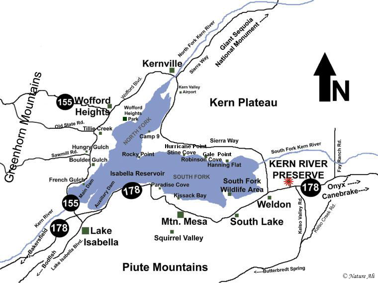
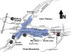
Isabella Reservoir - This huge body of water is so huge and deep, birding can be
a challenge. Best by boat. The lake has attracted some very rare coastal birds
in the past. From the shore one can see gulls, terns, grebes, shorebirds, and
kingfishers near the water's edge. To view either the main dam or auxiliary dam
enter the Sequoia National Forest Visitor Center from Hwy 155, continue on the
dirt road beyond the visitor center building, to the left takes you to the boat
launch on the main dam fork, to the right takes you to the Auxiliary Dam. The
reservoir is best viewed before the afternoon winds, which normally get brutal
around 1 p.m.
The next few paragraphs lead you on a tour around the reservoir from Hwy 155
which becomes Wofford Heights Blvd which then becomes Kernville Road, turning
right on Sierra Way, turning right on Hwy 178 back to Isabella.
Main Dam
- Winter this side has lot's of grebes, mergansers, loons, and other goodies.
The water can be viewed from the visitor center or from
French Gulch Marina off Hwy 155.
Keyesville south - enter
from Hwy 155 just across from the Sequoia NF Visitor
Center. Drive all the way down to the river bearing left at the bottom of the
hill. Good dipper and canyon wren territory.
Main Dam Campground - In winter this campground is locked but you can park at
the entrance along Hwy 155. The trees can hold many goodies. Four species of
sapsucker have been found here in winter. Along the river canyon wrens dance
with black phoebes.
French Gulch Marina - Enter off Hwy 155 between Lake Isabella and Wofford
Heights, park at the top of the hill and scope the main dam area. Best in the
morning before the wind picks up.
Tillie Creek Campground / North Fork Marina
– is
19.0 miles and takes about 25 minutes to get to from the Kern River Preserve.
1. Turn right onto Highway 178 westbound –
drive 12.6 miles
2. Take exit 43 onto Highway 155/Wofford
Heights turn right – drive 6.1 miles
3. Turn right onto Old State Rd toward the
reservoir – drive 0.3 miles
4. Turn right toward the Jesse James Trailer
Park/North Fork Marina, then turn immediately left onto a paved spur, flip a
u-turn and park on the dirt next to the pavement.
People use this to drive down to the shore so don't block the road. From
here you can walk through the campground or down to the shore of the reservoir
without fee. Walk into the campground keeping
right away from the campers. Do not use park on weekends or holidays
Ospreys and bald eagles (winter only) hang out on the snags in the
water. Phainopepla and other oak woodland species are found in the campground.
Peregrine Falcons hunt along the shoreline.
Wofford Heights Park - This small park is found off East Evans Road. At the Hwy
155/Evans Road junction turn right down toward the reservoir. Park and walk -
depends on your vehicle if you want to drive along the shore of the reservoir -
high clearance and good traction required. Drive or walk down to the willows
near the shore. Interesting species can sometimes be found hanging around the
willows between the park and North Fork Marina, for several years this has been
the winter hangout for a Northern Shrike.
Kernville - Trees and the river throughout town are hit or miss for osprey and
great blue heron. There are a few nice delis in town and Riverside Park is a
nice area to picnic along the perennial river. Near the bridge oak titmice and
white-breasted nuthatch can be found. At the end of Kernville road, if you turn left
it will take you upstream to Johnsondale, Giant Sequoia Monument (road closed in
winter), Sherman Pass and the Kern Plateau. Turn right to continue around the
reservoir.
Camp 9 -
This campground is found along Sierra Way to the east of Kernville. Along the shore, you will find one of the more
frequent hangouts for wintering Bald Eagles. A dark morph Red-tailed Hawk
frequents the telephone poles along Sierra Way by the entrance. The campground
is fee based, tell them you are birding and most of the time they will just let you drive
around. From
this point on, most of Sierra Way is frequented by
roadrunners and rock wrens so look along the rock/grassland edges for
these two species.
Hurricane Point - Not marked as such but you will know why this
is called this when
you encounter the winds at this turnout along Sierra Way, just
above Stine Cove,
it is a great spot to find birds of all types riding thermals along the
cliffs. In summer terns, in winter gulls, eagles, and other raptors. Below on
the reservoir is where you can see Western and Clark's grebes, American
White Pelicans, and waterfowl. Best viewed early in the morning before the wind
gets too brutal. Bring your scope for this spot.
Gale Point - This turnout is found above Robinson Cove, not much difference in
the winds, but the nickname hurricane point was already taken. Birding is
different here, birds nest on the metamorphic cliff above the road, and you get
better
views of the pelicans from this spot. A close inspection of the rock just below
the southern side of the cliff is strewn with bedrock mortars from the Umubflap
village of the Pahkanapil people that lived here before being displaced by
roughneck settlers in the 1850's. Look across Robinson Cove on the slopes
facing this vista, this is the end of a lime dike that cuts through the Piute
Mountains. Just above the dirt road on this slope is the furthest northern
Joshua Tree forest. These are pygmy Joshua trees, an unique variety of this plant
found nowhere else in the world. This population may disappear because
unfortunately most
developers ignore unique members of our planetary society in
order to line their pockets.
Hanning Flat - Enter this drive, keeping straight takes you along the old road
known as Patterson Lane. The rock pile is called Rabbit Island, named after the
reservoir was built, rabbits and other creatures took refuge here as the water
rose. The road gets very sandy here so walking is best beyond Rabbit Island.
Closer looks at the pelicans which stay on the spits of sand between here and Kissack Cove. This is the best area to find shorebirds. If you turn right as the
pavement ends, you can continue to drive toward a spring where icterids,
warblers, and wrens nest. Bearing left along the road under the hill takes you
along the lime dike, high clearance vehicles only on this bumpy rock strewn
trail. I have found teals, gadwalls, grebes, and blackbirds frequenting the
shallow water here.
South Fork Wildlife Area 1 - A part of the Sequoia National Forest this area is a
remnant of the great riparian ecosystem that once graced this valley. Endangered
and threatened species nest here. From Sierra Way there is a parking area
just north of the South Fork Kern Sierra Way bridge. Park and walk in.
Frequently flooded from November to June depending on rainfall.
 Kern River Preserve migrant corner trail - At the northeast corner of the Sierra
Way bridge there is a pedestrian bypass that leads to the migrant corner trail
(an unmaintained track use at your own risk).
In spring this corner is awash in migrants hundreds of Lawrence's Goldfinch have
been seen here. Walk the trail look up for desert species, look below for
riparian species. Walk about 3/4 mile to a meadow/marsh then turn back.
The trail is
2.3 miles and takes about 4 minutes to get to from the Kern River Preserve
headquarters.
Kern River Preserve migrant corner trail - At the northeast corner of the Sierra
Way bridge there is a pedestrian bypass that leads to the migrant corner trail
(an unmaintained track use at your own risk).
In spring this corner is awash in migrants hundreds of Lawrence's Goldfinch have
been seen here. Walk the trail look up for desert species, look below for
riparian species. Walk about 3/4 mile to a meadow/marsh then turn back.
The trail is
2.3 miles and takes about 4 minutes to get to from the Kern River Preserve
headquarters.
1. Turn right at Highway 178 westbound – drive
1.1 miles
2. Turn right onto Sierra Way - drive 1.2 miles
This is an uneven trail that is best during
migration. The trail is about 0.75 miles one-way.
Audubon Kern River Preserve - Home to breeding populations of Southwestern Willow
Flycatcher, Summer Tanager, and Western Yellow-billed Cuckoo
along with almost 100 other species of nesting birds.
South Fork Wildlife Area
2 - A part of the Sequoia National Forest this area is a
remnant of the great riparian ecosystem that once graced this valley. Endangered
and threatened species nest here. Enter from Hwy. 178 just east of South Lake
and just west of Sierra Way. Drive down a dirt road about 1/4 mile, the entrance
to the wildlife area is on your right. Park and walk in.
Can be flooded from November to June in high rainfall years, normally dry.
Kissack Cove - Continue driving along Hwy 178 back toward Lake Isabella. Drive
through the town of Mountain Mesa and just west there is an entrance to Kissack
Cove. See American White Pelicans, Osprey, California Gull,
Double-crested Cormorants from the shore. Scattered throughout the grassland, horned larks and pipits will flush.
At the east end there is a wetland that attracts waterfowl
and shorebirds.
Paradise Cove -
On the water north of Paradise Cove winter flocks of
western, Clark's and eared grebe number in the
hundreds.
Auxiliary Dam - Can also be entered from the South side off Highway 178 and
reach by entering campground entrance. Good deep water pelagic species found
here. Loons, grebes, and gulls.
Other areas in the Kern River Valley
Canebrake Ecological Reserve
–
is 9.7 miles and takes about 12 minutes to get to from the Kern River Preserve.
A 1400-acre wildlife sanctuary owned and
managed by the California Dept of Fish & Game. This is a
great birding spot for migrating and breeding birds. This area is home to
dozens of species absent or rare downstream. Canebrake is approximately 11-miles
east of Audubon's Kern River Preserve on Hwy 178. An ADA constructed trail leads
from the parking area off of Highway 178 through the Joshua tree woodland down
to a wooden bridge that crosses Canebrake Creek. The path then winds through a
site restored by Audubon and Fish & Game in the late 1990's and early 2000's.
The trail is 1.2 miles to a picnic table that sits below a
steep slope that leads to the Domelands Wilderness. As for birds, there is a
nesting colony of Tri-colored Blackbirds, nesting Summer Tanagers, Blue
Grosbeak, Yellow Warblers, Ladder-backed Woodpeckers, Nuttall's Woodpeckers, and
Song Sparrows. Lots of great vagrants migrate through in spring. Northern Parula
have been spotted here. An Eastern Phoebe spent the winter a few years ago. In
winter Buteos rule. Red-tailed Hawks and Ferruginous Hawks are common along with
occasional Rough-legged Hawks. Golden Eagles nest in the nearby mountains. Other
wildlife include: Raccoon, American Black Bear, Bobcat, Coyote, Mountain Lion,
Gray Fox, and various rodents.
1. Turn left onto Highway 178 eastbound – drive
9.7 miles. Public access is via a dirt parking lot on the north side of Highway
178 just before a big blind curve.
2. Turn left at the green gate where there is a
Canebrake Ecological Reserve sign. You need an able bodied person to open and
shut the gate at the entrance to the parking lot.
Trail of Hundred Giants –
is 48.0 miles and takes about 1 hour 25 minutes
from the Kern River Preserve.
1. Turn right at Highway 178 westbound – drive
1.1 miles
2. Turn right onto Sierra Way - drive 16.4
miles
3. Sierra Way morphs into Mountain-99 –
continue driving 21.1 miles
4. Mountain 99 morphs into Mountain 50 at Lloyd
Meadows Road continue to Western Divide Highway – drive 6.5 miles
5. Turn right onto Mountain 90/Western Divide
Hwy – drive 2.6 mi
6. There is a $5 (may increase) fee to park at
the trailhead. The trail is paved and suitable for wheelchairs but is only open
after the snow melts (May/June through November).
Greenhorn Summit/Shirley Meadow –
is 29.0 miles and takes about 44 minutes to get
to from the Kern River Preserve.
1. Turn right at Highway 178 westbound – drive
12.3 miles
2. Take exit 43 onto Highway 155/Wofford
Heights Blvd turn right – drive 6.5 miles
3. Sharp left at Highway 155 W/Evans Rd – drive
7.5 miles
4. Turn left at Rancheria Rd (signs for
Rancheria Rd/Shirley Meadows) – drive 2.2 miles
The parking area for Shirley Meadows is packed
when there is snow, best to park downhill in wide sections and bird from the
road. Caution: drivers pay zero attention to other people be aware that staying
to the side of the road is the best way to avoid an accident.